Navan grew from a modest Norman settlement into a booming commuter hub, and that rapid expansion has pushed development onto the drumlin clay slopes and alluvial flats along the Boyne and Blackwater rivers. Road cuts near the M3 extension and foundation excavations around Johnstown reveal just how quickly ground conditions can change across the town. What looks like uniform till from the surface often hides soft lenses or weathered limestone at depth, and that is where a MASW survey becomes essential. The team combines seismic refraction surveys to map top-of-rock with MASW profiling to extract shear wave velocity, giving a complete picture of subsurface stiffness without the need for extensive drilling. In a town where glacial deposits can vary from dense lodgement till to soft lacustrine silts within fifty metres, relying on just one investigation method leaves too much to chance. The VS30 value derived from a well-executed MASW line is the first number the structural designer needs to know for site classification under Eurocode 8.
Shear wave velocity is the soil parameter that connects geophysics directly to structural demand in Eurocode 8.
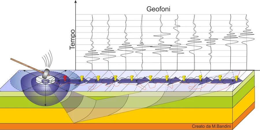
Methodology and scope
Local considerations
At 42 metres above sea level on its highest drumlin, Navan sits in a low-seismicity region by global standards, but the national annex to Eurocode 8 still requires site classification for structures of consequence class CC2 and above. The bigger risk in the Navan area is not strong shaking but the mischaracterisation of soft ground that can amplify even modest vibrations from quarry blasting or heavy traffic along the N51. A site incorrectly classified as ground type B when it is actually type D will have an underestimated design spectrum, potentially leading to insufficient reinforcement or foundation dimensions. The 2011 expansion of the Navan borehole network by Geological Survey Ireland confirmed the presence of deep alluvial channels near the Boyne that are invisible from surface mapping alone. A MASW line run perpendicular to the river can catch these buried channels and prevent the kind of differential settlement that shows up five years after handover.
Applicable standards
Eurocode 8 (EN 1998-1:2004) – Ground type classification from VS30, ASTM D4428/D4428M-14 – Crosshole seismic testing (adapted principles for surface wave), NEHRP Recommended Provisions for Seismic Regulations – Site class definitions, Irish National Annex to Eurocode 8 – I.S. EN 1998-1/NA:2010, ASCE 7-22 – Minimum Design Loads – Site classification by shear wave velocity
Associated technical services
VS30 Site Classification Surveys
Single or multiple MASW lines to determine the average shear wave velocity of the upper 30 metres, delivering the ground type letter (B, C, D) required for structural design under Eurocode 8.
2D Shear Wave Velocity Cross-Sections
Continuous MASW profiles along building footprints or road alignments, producing colour-contoured VS cross-sections that highlight lateral changes in stiffness across the site.
Combined MASW and Refraction Tomography
Integrated geophysical survey using both P-wave refraction and surface wave methods to map bedrock depth and soil stiffness in a single field campaign, reducing mobilisation costs.
Seismic Site Response Analysis Input
Preparation of shear wave velocity profiles formatted for DEEPSOIL, SHAKE, or equivalent software, including modulus reduction curves calibrated to the measured VS profile.
Typical parameters
Frequently asked questions
How much does a MASW survey cost for a residential site in Navan?
For a typical single-line MASW survey on a residential plot in the Navan area, the cost usually falls between €1,430 and €2,600, depending on the array length needed to reach 30 metres depth and the number of shot points. A two-line survey for a larger house or a site with suspected lateral variation will be at the upper end of that range. The final figure includes field acquisition, dispersion curve processing, inversion to a 1D VS profile, and a signed report with the VS30 ground classification.
What is the difference between MASW and seismic refraction for site investigation?
Seismic refraction gives us the P-wave velocity structure and is excellent for mapping top-of-rock and the water table. MASW extracts shear wave velocity, which is the parameter directly linked to soil stiffness and seismic site classification. In Navan's glacial till, a refraction survey might show a strong velocity contrast at the till-bedrock interface, while MASW tells us whether the till itself is stiff enough for ground type B or soft enough to warrant type C. We frequently run both methods along the same geophone spread to get complementary data from one field setup.
Can MASW work through tarmac or concrete surfaces in Navan's urban areas?
Yes, we can acquire MASW data through pavement by using shorter geophone spikes or by mounting the geophones on metal base plates coupled to the surface with plasticine or gypsum. The high-frequency end of the dispersion curve may lose some resolution on asphalt, but the low-frequency Rayleigh waves that control VS30 penetration are largely unaffected. For sites along the Athboy Road or in the town centre where breaking ground is not practical, this non-invasive approach keeps the survey moving without disrupting traffic or services.