Navan sits at roughly 42 m above sea level along the Boyne, but the real story lies underground. The town spreads over a mix of glacial tills and limestone-derived clays that shift from gravelly ridges near the river to silty pockets in the townlands further out. Our grain size analysis covers the full spectrum in one run: mechanical sieving for the coarse fraction and hydrometer for fines passing the 75 µm sieve. When foundations in Navan encounter unexpected silt lenses, the combined Afterberg limits and gradation data pin down the soil classification fast. For road subbase checks along the R147 corridor, we pair the hydrometer curve with a CBR assessment so the pavement design reflects what is actually in the ground, not a textbook assumption.
A single combined sieve-and-hydrometer test turns a bucket of Navan till into a defensible engineering classification in under 48 hours.
Methodology and scope
Local considerations
Navan's expansion from a mining and market town into a growing commuter hub for Dublin has pushed new housing estates onto marginal land where drainage and bearing capacity depend heavily on fines content. A gradation curve that reveals 35% silt and clay in a sandy gravel changes the compaction spec overnight; skip the hydrometer and that fine tail stays invisible until the first wet winter. The glacial history of the Boyne valley left behind stratified deposits where a half-metre change in depth can flip the grain size distribution. On one estate off the Trim Road, a layer of silty sand at 1.2 m depth went undetected by trial pits but showed clearly in the full combined analysis, triggering a lime stabilisation call before the floor slabs were poured. Because we run the sieve and hydrometer in the same lab under ISO 17025 accreditation, there is no gap between coarse and fine fractions for interpretation errors to creep in.
Applicable standards
ASTM D6913 / D6913M-17 — Particle-Size Distribution of Soils Using Sieve Analysis, ASTM D7928-17 — Particle-Size Distribution of Fine-Grained Soils Using the Sedimentation (Hydrometer) Analysis, ASTM D2487-17 — Unified Soil Classification System (USCS)
Associated technical services
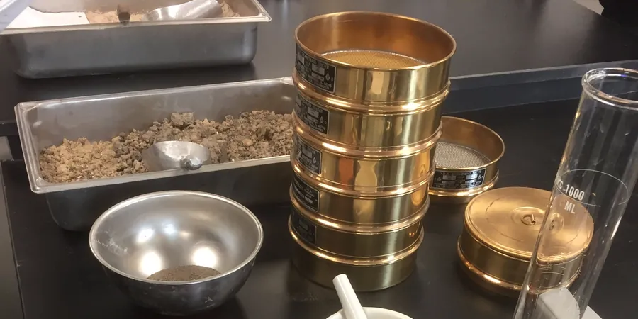
Combined Sieve & Hydrometer (Full Curve)
Mechanical sieving from 75 mm to 75 µm followed by hydrometer sedimentation on the minus-75 µm fraction. Delivers D10 through D60, Cu, Cc, and USCS classification in a single report. Suitable for foundation design, embankment quality control, and pavement subgrade verification.
Wash-Sieve Only (Coarse Fraction)
Wet sieving over the 75 µm sieve, oven drying, and dry sieving of the retained fraction. Reports percent gravel, sand, and fines by mass without the hydrometer curve. Fast option for concrete aggregate checks, drainage blanket gradation, and preliminary site screening.
Typical parameters
Frequently asked questions
How much does a grain size analysis cost in Navan?
A combined sieve and hydrometer test typically falls between €90 and €180 per sample, depending on the number of samples and whether express reporting is needed. Bulk pricing applies for five or more samples from the same site.
How long does the hydrometer test take to complete?
The hydrometer sedimentation phase runs for 24 hours by ASTM D7928, with readings at prescribed intervals. Including sample preparation, sieve analysis, and reporting, the full combined curve is usually delivered in two to three working days.
What sample size do you need from the site?
For a combined test we ask for roughly 2 kg of disturbed soil in a sealed bag. If gravel or cobbles are present, a 5 kg bulk sample gives a more representative coarse fraction for the sieve portion.